photo by Mike Matney
Mark Twain is a north side residential neighborhood that sits between Bellefontaine Cemetery and Interstate 70. It is a mixture of the past and present, that tests the positive and negative aspects of both.

photo by Sue Rakers

photo by Ann Aurbach

photo by Jackie Johnson

photo by Jason Bauman
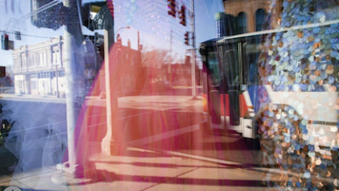
Mark Twain is a hard neighborhood to put a pin in. Visiting just a few years ago, we would have easily described the area as reassuringly stable (housing stock in good condition with a high percentage of inhabitance; the local public school, though closed due to low attendance, was tidied up for sale and intact; industry, long a staple of the community, was buzzing along; the local Alderman had successfully sponsored a city ordinance for redevelopment and was attempting a name change that would resonate more with residents), but now, any easy description is almost certain to contain asterisks. In 2020, walking along the streets of Mark Twain unveiled surprisingly more deterioration and abandonment than was expected, which suggests a quickening downward trajectory for the neighborhood- a troubling realization.
Though there is generally a balance of positive and negative change in St. Louis neighborhoods over the years, it is easy to see that north side communities are in a more fragile position than most south side ones. The factors that command deterioration, commercial and industrial investment, educational opportunities, job growth and crime, affect north side neighborhoods more dramatically than south side neighborhoods, and once declined, they are in a state exponentially harder to reverse the status of.
The existence of such disproportions are complicated to explain, but boil down to an essential willingness to ignore the problems of our city as a whole. For city leaders, when you have national attention for your growing midtown area, or such local love for the redevelopment efforts of The Grove or Cherokee Street, or dramatic increases in home values in places like Tower Grove South and East, it is easy to look past the neighborhoods where the trajectory has been opposite.

photo by Sue Rakers

photo by Joe Rakers

photo by Jason Gray

photo by Ann Aurbach
So why such disparity? Well:
“Beyond these national changes, St. Louis has been hurt by a set of factors that negatively impacted many cities but were disproportionately strong in St. Louis. The most famous, and historically detrimental, are the restrictive covenants and racial redlining that persisted in St. Louis to a degree not felt in many other cities.” –Rebound Neighborhoods in Older Industrial Cities: The Story of St. Louis, a report of the Public Policy Research Center of UMSL in cooperation with Washington University, 2014
The bottom line is that, as the result of decades of racially motivated disinvestment tactics combined with “White Flight”, large areas of especially north St. Louis remain predominantly African-American in population and with a high prevalence of poverty. Within these communities, many individuals that have had the means to relocate have done so, which has only worsened the rate of poverty, increased the incidence of low income rental properties, and dramatically lowered the overall population. The side effects of this are all of the things already mentioned, and I expect that the 2020 census will reflect lowered population, increase in poverty, and a proliferation of new renters in all of the neighborhoods that have seemingly taken a turn for the worse since 2010 (including Mark Twain).

photo by Mike Matney

photo by Jackie Johnson

photo by Jason Bauman

photo by Joe Rakers
Though the previous paragraphs have been dire, there are still things about Mark Twain to look at positively.
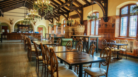
Much like many of its surrounding communities, like Penrose, O’Fallon, and Walnut Park, the Mark Twain neighborhood came into existence in the late 1800’s/early 1900’s as a commuter suburb to Downtown, following a new streetcar line along West Florissant. Originally named Harney Heights, after one of the community’s early developers, Mark Twain grew quickly into a primarily residential neighborhood of smaller middle class homes reminiscent of those found in the south St. Louis neighborhoods of North Hampton and Princeton Heights. Renowned St. Louis architect William B. Ittner designed the Harney Heights School (now the shuttered Mark Twain Elementary School), with its breathtaking towers, in 1912. Ittner was responsible for the design of over 400 school nationwide, as well as, the Continental-Life Building, Missouri Athletic Club and the Scottish Rite Cathedral in St. Louis.
Prior to World War II, Mark Twain added several manufacturers and other industrial operations that provided work for many residents. Unfortunately, the overseas relocation of much small manufacturing hit Mark Twain hard, beginning in the 1960’s, with most factories in the area closing in the following decades. Today, Archer Daniels Midland operates a massive milling operation that anchors what industry is left in the neighborhood.
As income opportunities waned and racial unease increased (the city’s racially restrictive deed covenants were legally ended in the 1950’s, freeing African-Americans to move to previously white neighborhoods, like Mark Twain), many working class whites relocated out of the city. This movement contributed to the first substantial population decline for the neighborhood, and by the early 1990’s, it had transitioned into a nearly completely black community. Though not as financially secure as in previous generations, Mark Twain nonetheless remained a proud, mostly pleasant place to raise a family. Part of Mark Twain’s relative stability, compared to other north side neighborhoods of the 1970s, 1980s, 1990s and 2000s, is due to the impact of community activists, like JoAnne Wayne and Evelyn Walker (the name change proposed by Alderman Troupe in 2011 was to “Wayne-Walker”), socially invested organizations, like the Royal Knights Athletic Association and some of the local church groups, and intervening interests from institutions like Bellefontaine Cemetery and Arboretum.

photo by Ann Aurbach

photo by Jason Bauman

photo by Jason Gray
Perhaps it is unfair to portray Mark Twain in such decline. After all, what can one visit on a cold, dreary winter’s morning really convey about the overall health of a community?
That said, even on such days, in most stable neighborhoods (even those fighting for a chance) we encounter residents, see businesses open and with customers, and generally find indicators of underlying forces at work. What’s more, it is the previous trips to the area, where aspects of decline can be seen compared to the present, that really suggest the resilience of a community and the trajectory of its overall health. Even so, Mark Twain is not as bad off as some other places around the city that we’ve encountered. I just hope that, on future Photo Floods, we stop seeing the trend of decline (in especially north side neighborhoods), and can report upon more of the successes (like last month’s O’Fallon or the enclave of black cultural institutions that we encountered in St. Louis Place). Certainly, these neighborhoods, and their people, deserve a better break.

photo by Mike Matney

photo by Jason Gray

photo by Joe Rakers

photo by Sue Rakers
Map is available here.