photograph by Dan Henrichs Photography, St. Louis
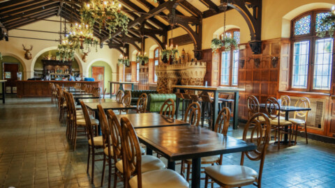
Once a prominent neighborhood for German immigrants to the city, St. Louis Place has since fallen onto hard times. Nonetheless, for almost every demolished building or crumbling facade here there is another amazing structure just begging for revitalization. Unfortunately, much like the Near North Riverfront, a municipal project threatens to demolish some of what remains.

photograph by Jason Gray

photograph by Sharon Keeler

photograph by John MacEnulty

photograph by Jeff Phillips

photograph by Jackie Johnson
In 1850, the city of St. Louis was a rapidly growing metropolis that civic leaders recognized would need extra room to prosper. By 1855, land was annexed to St. Louis that expanded its limits to cover almost 14 square miles. During this same period, a group of prosperous (and forward thinking) Irish immigrants planned a subdivision in pastoral North St. Louis near the Sheehan Quarries (among them were the Sheehan brothers). The original plan included a private place, like those found in the Central West End, along St. Louis Place Park, but because John O’Fallon donated this greenspace to the city, those would be “private” mansions materialized mostly along the neighborhood’s major thoroughfare, St. Louis Avenue. Nonetheless, the neighborhood grew to possess an architectural prominence that would be hard to match anywhere in the city.

photograph by John MacEnulty

photograph by Diane Piwowarczyk

photograph by Vivian Nieuwsma
By the time of the second wave of immigrants, Germans this time, to the area in the 1870’s-1880’s, St. Louis Place had grown into a densely populated mixture of large and small homes, industrial plants, pubs, churches, markets and more. The Germans also brought brewing to the neighborhood, and the massive Columbia Brewery complex (later Falstaff), built in 1891, is testament to just how well the north side could rival the south side on beer production. Today, the Brewery buildings have been converted into apartments, but the streets surrounding still possess a character of the time period. Prosperity and growth for the neighborhood continued until at least the 1950’s, when population began to decline. Now, the neighborhood has less people living in it than would have have attended church services on any typical Sunday during its peak era. Standing outside those massive religious structures, some now boarded up and surrounded by vacant lots, it is almost hard to imagine those throngs ever having existed there.

photograph by John MacEnulty

photograph by John MacEnulty

photograph by Jackie Johnson
Looking to the future, it is hard not to see the development occurring in the adjacent Old North Saint Louis, and hope for it to spread across the boarder. In some ways this is already happening; the neighborhood’s southeast sector had lots of people out walking pets or pushing baby carriages, and the buildings largely look to have seen some recent love. Meanwhile, along St. Louis Place, several organizations that focus upon the experiences of African-Americans, such as The Griot Museum of Black History, the Frederick A. Douglass Museum of African-American Vernacular Images, and the George B. Vashon Cultural Research Center, appear to be spurring an important revitalization mode that severs the notion that blighted neighborhoods are incapable of self-renewal. Unfortunately, looming over all of this slow growth is the proposal to raze a large section of the neighborhood (essentially, all of the buildings within a border bounded by Jefferson Avenue/Parnell Street, Montgomery Street, 22nd Street, and Cass Avenue), via Eminent Domain, for the relocation of the National Geospatial-Intelligence Agency. This would erase an area of the city already experiencing some rebirth, with much of its building stock still a good candidate for restoration. That said, it is almost impossible to fault the underlying merits of the project, which would retain millions of dollars for the city and keep a substantial provider of well-paying jobs, as well as, create new construction jobs in the interim. If the project had been confined to the original concept of locating it upon the former Pruitt-Igoe footprint, I doubt that there would be much reservation. Of course, if any of the promises that had been made long ago by Paul McKee’s NorthSide Redevelopment Proposal had actually materialized (instead of him allowing vacant properties to fester and decay), this conversation would likewise be much different.

photograph by Dan Henrichs Photography, St. Louis

photograph by Diane Piwowarczyk

photograph by Jackie Johnson

photograph by Dave Adams
At the moment, exploring St. Louis Place on foot with a camera is one of the most rewarding experiences in all of St. Louis, both because of visual variety and the friendly people that you meet there. Walking diagonally across the neighborhood, from the northwest to the southeast, feels at several points like you are crossing into other areas of the city or even the Midwest. Several enclaves throughout the neighborhood possess characteristics totally unique from one another, and are each worthy of individual looks. Many PFSTL Members remarked that two hours did not seem enough to get to the bottom of this place, and I agree. Now the question remains, “What will you discover there?”

photograph by Jason Gray

photograph by John MacEnulty

photograph by Dave Adams

photograph by Jeff Phillips
MAP:

Our endpoint for this Flood was La Mancha Coffeehouse, a fantastic cafe in Old North Saint Louis with a friendly staff and cozy seats. We can recommend the Breakfast Burrito, which filled us up after a morning exploring. They also have a Bottomless Cup of Coffee for the long, winter days that we have on the way (someday).

photograph by Jason Gray


