photo by Maureen Minich
Kingsway East is a small, north side neighborhood. Like most of the neighborhoods nearby it, Kingsway East’s present is underscored by so much of its past.

photo by Diana Linsley

photo by Ann Aurbach

photo by Sue Rakers

photo by Cathy Ray
In the earliest days of St. Louis and its neighbor, St. Charles, a route existed between the two that would become a portal of trade, delivering goods from the farthest reaches of the Louisiana Territory to the dozens of steamboats lining St. Louis’ bustling levee. This road was also the passage through which America’s ambitions of fame, fortune and sense of adventure were to pass for most of the 19th Century; this is the road that began the journey for both the Voyage of Discovery and the Oregon Trail.
In 1837, this road became a turnpike (one of Missouri’s first), and in 1865, it was macadamized, resulting in its current and familiar moniker of St. Charles Rock Road. Through St. Louis, it was known as Easton (Martin Luther King, Jr. Boulevard after 1972), which is where the story of Kingsway East begins.

photo by Kate Cawvey

photo by Vivian Nieuwsma

photo by Cathy Ray

photo by Mike Matney
Easton Avenue, like Gravois and Broadway, was among the city’s first and most important trade routes. It is not surprising then that development occurred along these routes early, even away from Downtown. The current neighborhood of Kingsway East began its life as part of a suburban development called Arlington Grove (a name that has found rejuvenation in a recent renovation project). The land for the development was owned by John W. Burd, who’s own stately living quarters were located downtown.
The legacy of this early community is in two schools (neither of which were located in what is now Kingsway East, but are still significant to its history). The Arlington School (the central element of the renovation project linked above) was designed by William B. Ittner, and constructed in 1898 as part of the St. Louis Public School System’s push toward updated facilities. The other school, the Christian Brothers College, was constructed in the 1880’s to replace it first facilities Downtown. The new College, on the site of what is today Sherman Park at MLK and Kingshighway, was a breathtaking, five-story building that was tragically destroyed in 1916 by one of the deadliest fires in St. Louis history. Had this building survived, it would be a city landmark, without a doubt. Following the fire, CBC relocated to their current address on Clayton Road.


images courtesy of Missouri Historical Society

photo by Ann Aurbach

photo by Vivian Nieuwsma

photo by Diane Sieckmann

photo by Sue Rakers
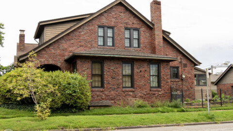
Most of the residential buildings visible today in Kingsway East are from a period after 1900. Arlington Grove (also referred to as Cote Brilliante or “Shining Hill”, after a Native-American mound that was destroyed for the construction of Christian Brothers College), no longer suburban following the city’s expansion of 1876, grew steadily following the introduction of mass transit and industrial rail services to the area after the Civil War. By the 1940’s, the commercial district along Easton Avenue, extending into Wellston and Pagedale, was among the busiest in the whole city. The neighborhood surrounding this district, including what is now Kingsway East, was full of tidy, middle class homes- homes of fond memories to generations of St. Louisans.
The neighborhood’s prosperity was double-edged, however, as the racially restrictive deed covenants and redlining that reserved the area for whites had the dual effect of positioning the community for decline in the era following white flight. This, combined with the diminishing of Easton’s use as a major thoroughfare after the construction of the Federal Highway System and the removal of the streetcar system, assured the staggering population decline and disinvestment that followed. Nearby, Wells Goodfellow and Hamilton Heights show this even more dramatically.
Nonetheless, a resilient and primarily African-American community arose in Kingsway East, which in conjunction with several church and community organizations, is continually striving to overcome many of the challenges already mentioned.
In 1972, Easton Avenue was permanently renamed Martin Luther King Jr. Boulevard. Though this move was originally championed by some of the city’s civil rights leaders, it is not without its controversy. In a 2018 article, Post-Dispatch writer Doug Moore referred to the street as a place where “hope and despair collide,” a sentiment in line with critics who question why streets named after Dr. King are always in “rundown parts of town.” Perhaps, as a society, we will one day be in a position to answer that question directly, and what’s more, be in a position ready to address it, but that moment is not now.

photo by Diana Linsley

photo by Maureen Minich
Today, Kingsway East is a neighborhood with its history on full display. It is a community where the challenges that residents face, and have faced historically, are easy to see, though it is also plain that people living here have a commitment to one another- a commitment to a neighborhood with a brighter future.

photo by Mike Matney

photo by Ann Aurbach

photo by Diane Sieckmann

photo by Kate Cawvey