photograph by Janet Henrichs
Much like The Patch, Mount Pleasant is a neighborhood in south St. Louis most often referred to by the name of a larger adjoining community (Dutchtown). Nonetheless, Mt. Pleasant is a place with a character all its own; one featuring an extremely varied architectural tradition ranging from the last remaining Indian mound in the city, Sugarloaf Mound, to the soaring nave of St. Anthony of Padua. Located along the historic trade route between St. Louis and Carondelet, Mt. Pleasant has a storied history, impacted devastatingly by the interstate highway that cleaves it in two.

photograph by Theresa Harter
photograph by Sasi Suruliraj

photograph by Amanda Miller

photograph by Anne Warfield
photograph by Ann Aurbach
In the latter half of the 18th century, a small settlement, about 7 miles south of the Arch, was established almost simultaneously to that of St. Louis. This settlement was known initially as Louisbourg, but later came to be called Carondelet (after the Governor of Spanish Louisiana). In the earliest days, the colonies depended upon each other for opposite needs; essentially, Carondelet was poor and St. Louis was hungry, so a trade route was established. Running south from the Old Courthouse in downtown St. Louis, Broadway Street now comprises the historic trade route, and eventually culminates as a commercial corridor in Carondelet. As St. Louis grew, it first expanded north and south along the Mississippi River, and therefore, many early neighborhoods began to burgeon along Broadway. When the Iron Mountain Railway was constructed between St. Louis and Iron Mountain, Mo. in 1874, it ran roughly parallel to Broadway in the city limits, and helped accelerate development in the corridor surrounding it. One of the many communities that grew out of the relationship between Carondelet, the Iron Mountain Railway and St. Louis was Mount Pleasant.

photograph by Sasi Suruliraj

photograph by Sasi Suruliraj

photograph by Dan Henrichs Photography, St. Louis
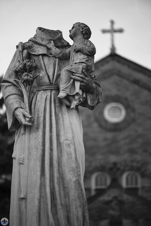
After the Louisiana Purchase from France by the fledgling United States, St. Louis (perpetually a home to immigrants from all places) began to swell with Americans moving westward. Previous to this time, most city residents were Catholic; however, the Americans brought with them Protestantism, which was a point of contention for the Creole residents already here. Catholicism regained momentum in the city when Germans identifying with the Roman Catholic Church began to settle throughout the region, especially in neighborhoods in south St. Louis. By the mid-19th century, Mount Pleasant, and surrounding neighborhoods like Dutchtown, were ethnically, predominantly German. Residents of the area could travel to masses in either Carondelet or Soulard, but as the population continued to bloom, it became readily apparent that a parish was needed closer to home. In 1863, construction began on the neighborhood’s first permanent church, St. Anthony of Padua, which was completed in 1869. The building, a Gothic Revival design, was assembled with limestone quarried nearby. Much like nearby Jesuits, the Franciscans believed that educating children was an important cause, and so St. Anthony’s functioned also as a school almost from the very beginning. In subsequent years, the parish’s campus was expanded with separate buildings added to house schools for boys and girls. In 1910, a larger Romanesque-derived church replaced the older building in order to support St. Anthony’s much expanded congregation. Inside this structure, vertical shafts of columns support a ribbed vault ceiling soaring above the nave, while several painted murals and stained glass windows further decorate the plan throughout. St. Anthony’s of Padua is a beautiful church whose parish continues to positively impact the surrounding neighborhood and beyond.

photograph by Janet Henrichs

photograph by Theresa Harter

photograph by Jasmine Bell

photograph by Theresa Harter
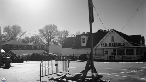
From 1850 to 1950, Mount Pleasant prospered, evolving from a quaint rural community to an unmistakably urban one. However, times began to change in 1956, when the Federal Highway Aid Act approved for the construction of an interstate highway nationwide, and Missouri was quick to jump on board. Unlike some St. Louis neighborhoods, like The Hill, whose community groups helped to direct the course of the interstate through their areas, Mount Pleasant was cleaved almost perfectly in half by the new road. The effect of this was that the neighborhood’s growing commercial district, on Meramec near St. Anthony’s, was cut-off entirely from its industrial corridor, along the river and railroad. Furthermore, the highway meant that truck traffic could circumnavigate the commercial area for the industrial one. Resultantly, Mount Pleasant’s commercial district never fully matured, and the neighborhood, as a whole, became largely dependent upon those nearby that were less affected by the highway construction. So it was that Mount Pleasant would forevermore be fixated upon the minds of St. Louisans as a section of Dutchtown. That said, the isolation caused by the interstate did help to preserve one aspect of the neighborhood. Sugarloaf Mound, the last of the Native American ceremonial mounds left in St. Louis (the others were removed for urban development), sits upon land effectively cut off from anyone not directly intending to go there, a positive result of the highway’s otherwise ominous presence.

photograph by Janet Henrichs
Once upon a time, St. Louis earned the nickname “Mound City” for its abundance of such structures, which were leftover from one of North America’s largest pre-columbian civilizations. The Mississippians had their headquarters near Cahokia, Illinois where they communed in a society larger than London at the time, used sophisticated crop irrigation techniques, built complex wood constructions relating to navigation and the heavens, and enjoyed a trade network stretching from the Great Lakes to the Gulf of Mexico and from the Appalachians to the Rockies. Although no one knows exactly what happened to the Mississippians at Cahokia, or where they went, the modern Osage Nation believes themselves to be descendants. Owing to this heritage, the Osage Tribe purchased Sugarloaf Mound in 2009, and plan to restore the Mound by removing the buildings currently resting upon it. In addition, their intentions are to build an educational center nearby to communicate the legacy and history of the mound builders.

photograph by Anne Warfield

photograph by Janet Henrichs

photograph by Dan Henrichs Photography, St. Louis
Today, Mount Pleasant strains against the urban decay that has suffered the city since the 1960’s. The neighborhood has many positive features despite the periodic empty buildings or neglected lots. One such agency is the Mt. Pleasant Neighborhood Association, active since the 1950’s, which strives to unite the community towards a common purpose. Of course, there is also the ever present St. Anthony’s and its devoted parishioners.

photograph by Ann Aurbach

photograph by Sasi Suruliraj

photograph by Anne Warfield
MAP:

Our endpoint was Original Crusoe’s Restaurant and Pub which was a delightful spot to grab lunch on an unusually hot day in January.

photograph by Dan Henrichs Photography, St. Louis