photo by Ann Aurbach
We kicked off our cold weather Floods in 2018 with a revisit to the North Side’s North Riverfront neighborhood to complete what we started. This section is smaller than the area where our first Flood here was set, but like the first one, getting around was tricky given the amount of industrial sites.

photo by James Palmour

photo by Ryan Stanley

photo by Mike Matney

photo by Jason Gray
Thirty Floods ago, we visited the lower section of North Riverfront, and included most of the relatively short (by St. Louis standards) history of the neighborhood in that article. Nonetheless, there is always more to see, and always more to write about in this river city.

photo by Ryan Stanley

photo by Ann Aurbach

photo by James Palmour

photo by Mike Matney
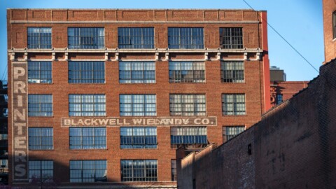
By middle of last century, St. Louis had a plethora of modern industrial districts, mostly along the riverfront but also along other shipping lanes, which it hoped would both attract and retain manufacturing in the area. North Riverfront hummed with activity during this time, though many manufacturers eventually moved operations away from the urban core. Today, surprisingly, much of that activity remains, though some of the warehouses and shipping complexes in this part of the neighborhood have been converted to more utilitarian uses, like junkyards. A few years ago, a North Riverfront Land Use Plan was presented to the City’s Planning Commission, designating the entire riverfront area north of Downtown as the North Riverfront Commerce Corridor. Certainly, there are shades of the city’s mid-1960’s push of Kosciusko as its industrial “savior” in this, but at least there seems to be some hindsight shown toward this effort, including preserving a portion of the Riverfront as an accessible, natural habitat. A slow rollout of aspects of this plan has been in effect since.

photo by Jason Gray

photo by Ryan Stanley

photo by Ann Aurbach

photo by Mike Matney
North Riverfront, in terms of this Flood, includes no private residences (that we are aware of), and because the businesses here take up such a large footprint, and are all posted as private property, we essentially had to “walk around” the section we were concentrating on, photographing either into those businesses or outside of the neighborhood. One notable exception is along the Riverfront Trail, which along the eastern boundary of what we explored, runs parallel to the section of the North Riverfront Land Use Plan earmarked as the Natural Riverfront District. There we were able to get breathtaking views of the Mississippi River and Downtown St. Louis. We even encountered a huge rafter of wild turkeys!

photo by Ann Aurbach

photo by Jason Gray

photo by James Palmour
Is it worth a walk through this part of North Riverfront today? The answer is largely, no, and we would add that it is actually quite dangerous to do so, given that the roads have no sidewalks and semi-trucks whip by, inviting a lethal misstep. An exception however, is the remarkable Riverfront Trail, which is beautiful, steeped in history, and can be a refreshing escape from city life.

photo by Ryan Stanley

photo by James Palmour

photo by Mike Matney

photo by Jason Gray
MAP: