
photograph by Kara Schoen
Botanical Heights is an interesting case study in urban redevelopment. What was once a supplemental community to Shaw, McRee Town fell into decay when the I-44 interstate plowed its way through, and severed the neighborhood off from its southern connections. Over time, building abandonment/ruination and crime engulfed McRee Town. Eventually, a plan was hatched to demolish the buildings that could not be saved (and some that could), and to construct a brand new urban community in place of the old, called Botanical Heights. While there is some controversy over how well that vision was executed, certainly, no one can argue with some of the recent successes of the new neighborhood (especially nearby the intersection of Tower Grove and McRee).
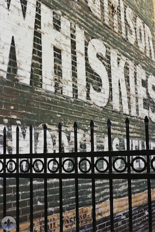
For photography, this neighborhood combines a lot of interesting visual draws ranging from modern infill housing to the old Star Tobacco factory complex, and from rusty railroad cars to a fantastically repurposed filling station.

photograph by James Palmour

photograph by Jason Gray

photograph by Shirley Moore

photograph by Robert Rohe
The story of St. Louis has traditionally been one of a scrappy colonnial-era city having gone from a prolonged and resplendent boon period to one of a decaying metastasis. The tellers of this tale usually spoke of what was or what could have been, and regarded the city itself as a sinking (if not already sunken) ship. However, current residents have proposed a rewrite, and substantial work is ongoing to ensure that the next chapter added is one of rebirth. From the previous success of Lafayette Square as a redevelopment project to the current re-envisioning of Cherokee Street as a creative district, many of the city’s grassroots, revitalization efforts have started to help earn St. Louis national attention (ranging from The Huffington Post to USA Today). Despite having lost, to decline or demolition, a building stock that would flatten the character of most younger cities, St. Louis continues to offer a sense of place that is unique among American metropolises. Punctuated by red brick and written in the manner of the throngs of immigrants who have called the city home, the city boasts an incredible diversity of architecture, so it is no surprise then that buildings form the crux of the argument over a recent redevelopment project called “Botanical Heights” (formerly the McRee Town neighborhood).

photograph by Scott Jackson

photograph by Chris Naffziger

photograph by Jason Gray
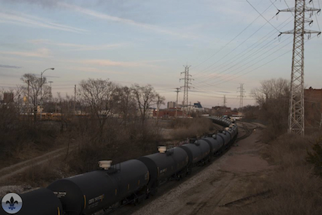
Two structures loom over the Botanical Heights neighborhood, both of which are synonymous to the growth and decline of the area. In the north, the former Liggett and Myers Tobacco Company (Star Tobacco) manufacturing plant was once the world’s largest supplier of plug chewing tobacco. During the late 1800’s, workers established residences nearby, and the McRee Town neighborhood flourished into being. Though generally plain, the brick homes were spacious and well-built, and occasionally featured novel ornamentation. Nearly one hundred years later, the cigarette business had long since moved on, as did manufacturing jobs and many McRee Town residents. Still, the neighborhood was placed on the National Historic Register in 1987, but continued abandonment and neglect threatened. In 1973, the second principal landmark was constructed along the southern border of McRee Town, which proved to be an even greater force of decline than the loss of manufacturing. Interstate 44 cleaved its way through, and placed the neighborhood in a state of veritable isolation. This physical trait meant that, as surrounding neighborhoods (like Lafayette Square and Shaw) began to experience redevelopment in the 1980’s and 1990’s, McRee Town suffered decline at a rate exponential to their growth. By 2003, when the transition towards Botanical Heights was first mobilized, McRee Town was well known throughout St. Louis for crime, especially drug trafficking.

photograph by Scott Jackson

photograph by Victoria Rohe

photograph by Jason Gray
In the late 1990’s, crime activity from McRee Town began to spill over into the Shaw neighborhood, an especially alarming trend for the Missouri Botanical Garden, located nearby. Since the Garden’s inception, the surrounding Shaw neighborhood has been an insulating factor. Comprised mostly of stately homes and well-appointed apartments, Shaw began to experience its own form of degradation relative to its proximity to McRee, and redevelopers saw this as a roadblock to their work there. To affront the problem, the Garden and several Neighborhood Associations formed the Garden District Commission, a nonprofit, to enact change in McRee Town. Eventually, a plan emerged to raze nearly 300 buildings in McRee Town, through Eminent Domain, and reconstruct modern dwellings geared toward the middle class. Surrounding these homes, a sustainable community, called Botanical Heights, they felt would emerge.

photograph by Kara Schoen

photograph by Kara Schoen

photograph by Scott Jackson
photograph by Jeni Kulka
The redevelopment raised over $10 million dollars, and many supporters; however, opponents were equally numerous. Detractors of the plan cited that the effort needlessly demolished many historically significant buildings (arguments range that 30-75% of the former McRee Town homes could have been restored), that more jobs would have been created through renovation than through new construction, and perhaps most significantly, that the poorest of the neighborhood’s previous residents would be displaced without new housing prospects. Protests transpired and signs declaring “no eminent domain” and “no clear cutting” emerged, but the project continued anyway.

photograph by James Palmour
photograph by Ann Aurbach

photograph by Jason Gray
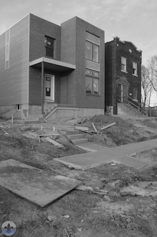
Today, with a warm sun fading over the seemingly thriving intersection of McRee and Tower Grove Avenues, it is hard to argue that a greater good was not achieved. The neighborhood is filling again with families, many of who enjoy the prospects offered by developers like UIC (whose projects in the neighborhood include green housing and a community garden with orchard), a nationally ranked charter school, and restaurants, including the much revered, Olio and Elaia. Sure, some of the infill homes, especially in the eastern areas of Botanical Heights resemble the reviled suburban-style tract housing that impairs the redevelopment efforts in places like The Gate neighborhood. However, there are bright lights here; the new constructions and renovations of existing buildings by UIC are mostly shining examples of thoughtful design that take into account how homes shape communities (and how communities should inform building design). Whether or not Botanical Heights was worth the expense of achieving it is up to the reader, but there is little doubt that, at least here, progress has been made towards that next chapter in the story of St. Louis.
photograph by Amanda Miller

photograph by Amanda Miller
MAP:

Our endpoint for Photo Flood 20 was the Atomic Cowboy (not the endpoint on the map) on Manchester, just outside of Botanical Heights. Atomic Cowboy was a great place to unwind with a beer, show off some photos, and eat delicious fish tacos.

photograph by Washington University Medical Center Redevelopment Corporation


